A 4.3 Magnitude Earthquake Hits Gerash, Iran: USGS Reports Shallow Tremor in Seismically Active Region.
A 4.3 magnitude earthquake struck near Gerash, Iran, on March 3, 2026. USGS reported a shallow 10 km tremor in Fars Province. Learn about the impact, tectonic causes, and seismic risks in Iran.
Gerash Iran earthquake
4.3 Magnitude Earthquake Hits Gerash, Iran – USGS Reports Shallow Tremor
A 4.3 magnitude earthquake near Gerash, Iran, shook parts of Fars Province on 3 March 2026, according to data released by the United States Geological Survey (USGS). The moderate tremor occurred at a shallow depth of 10 kilometres, making it noticeable across several nearby communities despite causing no immediate reports of casualties or major structural damage.
The earthquake struck at approximately 10:24 AM local time (Tehran time), with the epicentre located around 46–56 kilometres from Gerash, a city in southern Iran known for its traditional architecture, date palm cultivation, and proximity to the tectonically active Zagros mountain region.
Residents across Gerash and neighbouring areas reported brief but noticeable shaking. While the tremor generated concern among local communities, authorities confirmed that no significant disruptions to public services, transport networks, or critical infrastructure had been recorded.
USGS Confirms Shallow Earthquake Near Gerash
According to the USGS, the earthquake registered a magnitude of 4.3 and occurred at a depth of approximately 10 km (6.2 miles). Seismic monitoring organisations, including VolcanoDiscovery, initially recorded slightly different measurements, with some preliminary estimates placing the event at magnitude 4.4.
Shallow earthquakes are often felt more strongly at the surface because seismic energy has less distance to travel before reaching populated areas. Fortunately, this event remained within the moderate range and did not produce severe ground shaking capable of causing widespread destruction.
Gerash, situated about 200 kilometres south-east of Shiraz, lies within one of Iran's most active seismic zones. The region experiences frequent low-to-moderate earthquakes due to ongoing tectonic movements beneath the Zagros Mountains.
On Tuesday, March 3, 2026, a moderate magnitude 4.3 earthquake rattled the Gerash region in southern Iran's Fars Province, according to the United States Geological Survey (USGS).
The tremor, occurring at a shallow depth of 10 km (approximately 6.21 miles), was felt by residents in the vicinity but resulted in no immediate reports of casualties, major structural damage, or significant disruptions. The epicenter was located roughly 46-56 km SSW (or NNW in some refined reports) of Gerash, a small city in a rural, arid area known for its date palms, traditional architecture, and proximity to the seismically active Zagros fold and thrust belt.
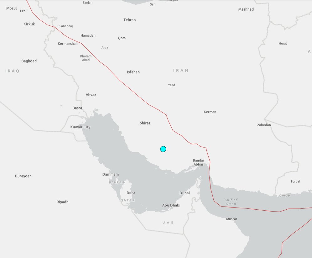
The quake struck around 10:24 AM local time (Tehran time, GMT+3:30), equivalent to approximately 6:54 UTC. Initial data from the USGS placed the magnitude at 4.3 mb (body-wave magnitude), with some monitoring agencies like VolcanoDiscovery noting a slight variance to 4.4 in preliminary assessments. The shallow focal depth is typical for events in this tectonic zone, where compressional forces from plate convergence generate frequent moderate quakes.
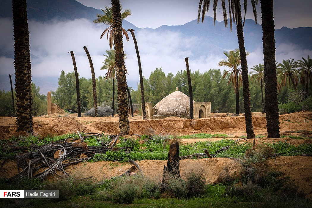
Gerash, with a population of around 25,000-30,000, lies in Fars Province, about 200 km southeast of Shiraz and inland from the Persian Gulf coast. The region features a mix of desert landscapes, palm groves, and small villages, with traditional mud-brick structures and modern low-rise buildings. Residents reported feeling noticeable shaking—described as "moderate" on the Modified Mercalli Intensity scale (likely III-IV near the epicenter)—causing brief alarm but no widespread panic.

Tectonic Setting: Why Iran Experiences Frequent Earthquakes.
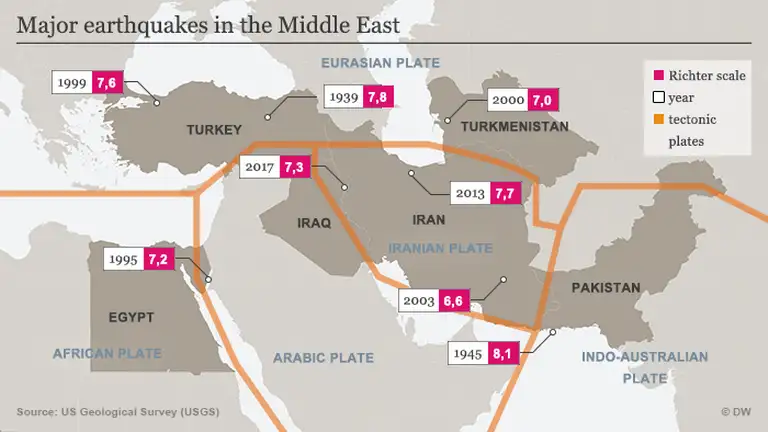
Iran is one of the most seismically active countries in the world, sitting at the collision boundary between the Arabian Plate and the Eurasian Plate. The Arabian Plate is moving northward at about 2-3 cm per year, pushing into Eurasia and creating the Zagros Mountains—a massive fold-thrust belt stretching across southwestern Iran. This ongoing compression builds immense stress along faults, releasing energy through earthquakes.Why Does Iran Experience So Many Earthquakes?
Iran ranks among the world's most earthquake-prone countries because it sits at the collision boundary between the Arabian Plate and the Eurasian Plate. The northward movement of the Arabian Plate continuously compresses the Earth's crust, creating immense geological stress.
This pressure has formed the Zagros mountain range and generated numerous active fault systems across the country. As stress accumulates along these faults, it is periodically released through earthquakes of varying magnitudes.
The Gerash region falls within the southern section of the Zagros Fold and Thrust Belt, where shallow seismic activity is common. Thousands of earthquakes are recorded in Iran every year, although most are too small to cause significant damage.
Local Impact and Emergency Response
Iranian authorities reported no confirmed injuries, fatalities, or major damage following the earthquake. Emergency response teams and local officials carried out precautionary inspections of schools, public buildings, healthcare facilities, and residential areas.
Nearby towns including Jahrom and Khonj also experienced light to moderate shaking. Social media users described objects rattling, doors shaking, and brief swaying sensations inside buildings.
The Iranian Red Crescent Society remained on standby while engineers assessed vulnerable structures, particularly older mud-brick homes that are more susceptible to earthquake damage. No power outages, landslides, fires, or secondary hazards were reported.
Importance of Earthquake Preparedness
Although this earthquake caused minimal disruption, experts stress that even moderate tremors serve as important reminders of the need for preparedness. Iran has invested significantly in public awareness campaigns, earthquake-resistant construction standards, and emergency response planning following several devastating earthquakes over the past decades.
Residents are encouraged to maintain emergency kits, secure heavy furniture, and familiarise themselves with safety procedures such as "Drop, Cover, and Hold On". Seismologists also continue to monitor the region for possible aftershocks, which commonly follow moderate earthquakes, although they are usually weaker than the main event.
Online Speculation Amid Regional Tensions
The timing of the earthquake attracted attention online due to ongoing geopolitical tensions in the Middle East. Some social media users speculated whether the tremor could be linked to military activity, underground explosions, or nuclear testing.
However, seismologists and international monitoring agencies quickly dismissed these theories. Earthquake waveform analysis showed characteristics consistent with natural tectonic activity associated with the Zagros fault system.
Experts noted that nuclear tests produce unique seismic signatures that can be detected by global monitoring networks. No evidence suggested any connection between the Gerash earthquake and military or nuclear-related activities.
Historical Earthquakes in Iran
Iran has experienced several devastating earthquakes throughout its history, highlighting the country's significant seismic risk.
Major Earthquakes in Iran
-
2003 Bam Earthquake (M6.6): More than 26,000 people lost their lives.
-
2017 Kermanshah Earthquake (M7.3): Hundreds were killed and thousands injured.
-
Frequent Zagros Earthquakes (M4–M5): Regular seismic events occur throughout southern and western Iran.
The Gerash area falls within the southern Zagros, where thrust faults dominate. Shallow earthquakes here are common, as the deformation is accommodated by folding and faulting rather than deep subduction. Historical data shows thousands of events annually in Iran, with magnitudes 4-5 occurring regularly. Larger, destructive quakes (M6+) have struck nearby in the past, such as the 2003 Bam earthquake (M6.6, over 26,000 deaths) or the 2017 Kermanshah quake (M7.3).
A magnitude 4.3 event is considered moderate: strong enough to be felt widely (up to 50-100 km away under ideal conditions) and potentially cause minor damage like cracked plaster or fallen objects in poorly constructed buildings, but rarely catastrophic. Building codes in rural Iran vary, and older adobe structures are vulnerable, though modern reinforcements help mitigate risks.
Immediate Impact and Response
As of March 4, 2026, Iranian authorities and local media reported no confirmed injuries, fatalities, or major infrastructure damage from the March 3 tremor. The event was widely felt in nearby towns like Jahrom and Khonj, with some social media users posting about momentary swaying or rattling items. Emergency services in Fars Province remained on alert, conducting routine inspections of public buildings, schools, and mosques.
No power outages, landslides, or secondary hazards (e.g., fires from gas leaks) were documented. The Iranian Red Crescent Society and local crisis management teams mobilized for precautionary assessments, especially in rural villages where older homes predominate. Seismologists emphasized that this quake aligns with "routine tectonic activity" along the Zagros fault system—no unusual patterns suggested induced seismicity or external triggers.Speculations and Context Amid Regional Tensions
The timing of the earthquake—amid escalating military tensions involving Iran, Israel, and the United States—sparked widespread online speculation. Social media users questioned whether the tremor could stem from an underground nuclear test, military strike, or explosion at a nearby facility. Theories proliferated due to the shallow depth (typical for both natural quakes and contained nuclear tests) and reports of heightened regional conflict.
 However, experts quickly dismissed these claims. Nuclear tests typically produce distinct seismic signatures (higher frequency waves, specific depth patterns) detectable by global monitoring networks like the Comprehensive Nuclear-Test-Ban Treaty Organization (CTBTO).
The USGS and other agencies classified the event as tectonic, with waveform analysis showing thrust-fault characteristics consistent with Zagros compression. The UN's International Atomic Energy Agency (IAEA) and U.S. monitoring entities reportedly found no evidence of nuclear activity or damage to sites.
The quake occurred against a backdrop of geopolitical strain, with ongoing airstrikes and retaliatory actions in the Middle East. Some outlets noted the irony of "nature striking too" amid human conflict, but seismologists reiterated Iran's high baseline seismic risk—independent of external events.
Historical Comparison and Seismic Risk in Iran
Iran averages several magnitude 4+ quakes monthly. Notable events include:
2003 Bam (M6.6): Devastated ancient city, killing over 26,000.
2017 Kermanshah (M7.3): Border region, hundreds dead.
Frequent M4-5 swarms in Zagros, often causing minor damage.
Gerash itself has experienced smaller tremors historically, but no major destructive quakes in recent decades. The area's risk stems from population density in vulnerable structures and proximity to active faults.
Public awareness campaigns in Iran promote "drop, cover, hold on" drills and retrofitting. International aid and USGS partnerships aid monitoring via the Global Seismographic Network.
Broader Implications
This minor event serves as a reminder of Iran's vulnerability. Even small quakes can exacerbate existing stresses—economic, infrastructural, and social—especially during instability. Authorities urged calm while monitoring for aftershocks (expected but typically smaller).
As details emerge, the focus remains on preparedness. The USGS continues refining data; residents are advised to secure heavy objects and prepare emergency kits.
In summary, the March 3, 2026, magnitude 4.3 quake near Gerash was a routine seismic release in a highly active zone—no cause for alarm beyond standard caution. It underscores the need for ongoing vigilance in one of Earth's most earthquake-prone nations.
The 4.3 magnitude earthquake near Gerash, Iran, reported by the USGS on 3 March 2026, was a routine seismic event within one of the world's most active tectonic regions. While the shallow tremor was felt by residents across parts of Fars Province, no serious damage or casualties were reported.
As Iran continues to face frequent earthquakes due to the collision of major tectonic plates, preparedness, resilient infrastructure, and public awareness remain essential. Although this event was moderate, it highlights the importance of remaining vigilant in a country where seismic activity is a constant reality.
Frequently Asked Questions (FAQ)
How strong was the earthquake in Gerash, Iran?
The earthquake measured 4.3 on the Richter scale, according to the USGS.
When did the Gerash earthquake occur?
The tremor occurred on 3 March 2026 at approximately 10:24 AM local time.
Where was the epicentre located?
The epicentre was located around 46–56 kilometres from Gerash in Iran's Fars Province.
Was there any damage reported?
No major damage, injuries, or fatalities were reported immediately after the earthquake.
Why are earthquakes common in Iran?
Iran sits on the boundary between the Arabian and Eurasian tectonic plates, making it one of the most seismically active countries in the world.


Comments
Post a Comment