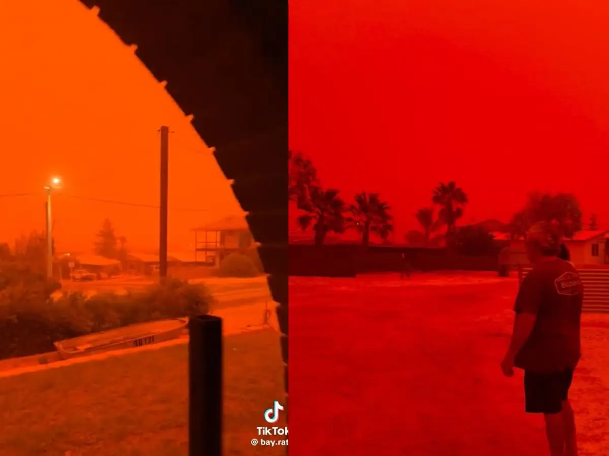
 'Apocalyptic' Red Sky in Australia Ahead of Tropical Cyclone Narelle
'Apocalyptic' Red Sky in Australia Ahead of Tropical Cyclone Narelle: A dramatic blood-red sky stunned residents in Western Australia as Tropical Cyclone Narelle approached in late March 2026.
The eerie, crimson glow — captured vividly in Shark Bay near Denham and in Karratha on the Pilbara coast — turned daylight into an otherworldly dusk, prompting descriptions like “incredibly eerie,” “apocalyptic,” and “the sky issuing a final warning.” The phenomenon was triggered by the cyclone’s powerful winds lifting massive amounts of iron-rich red desert dust into the atmosphere, creating a rare and striking visual spectacle.3333
Australia Skies Turn Blood Red Ahead of Tropical Cyclone.
On March 27, 2026, videos and photos from Shark Bay Caravan Park and surrounding areas showed the horizon bathed in deep blood-red and orange hues. The sky appeared to blot out the sun, drastically reducing visibility and casting an ominous tint over the landscape. Similar scenes were reported in Karratha and other parts of the Pilbara region as the storm system drew closer.
&imwidth=800&imheight=600&format=webp&quality=medium)
Apocalyptic' red sky in Australia ahead of Tropical Cyclone Narelle.
Apocalyptic' red sky in Australia ahead of Tropical Cyclone Narelle.
The Science Behind the Eerie Red Glow
The blood-red sky was not a filter, AI generation, or cinematic effect — it was a natural atmospheric phenomenon driven by light scattering and massive dust mobilisation.
Normally, the daytime sky appears blue due to Rayleigh scattering: sunlight interacts with small air molecules (nitrogen and oxygen), which scatter shorter blue and violet wavelengths more effectively while allowing longer red wavelengths to pass through more directly.
However, when large particles such as dust, sand, or mineral aerosols enter the atmosphere — as happened here — Mie scattering dominates. These larger particles (often 1–10 micrometres in size) scatter all wavelengths more equally but tend to enhance red and orange tones, especially when the sun is at a lower angle or when the dust layer is thick.
Apocalyptic Red Sky in Australia as Tropical Cyclone Narelle Approaches — Here's Why Did the Sky Turn Red?
In Western Australia, Tropical Cyclone Narelle’s strong winds vacuumed up fine, iron-oxide-rich red soil from the arid interior. Iron-rich dust particles are particularly effective at reflecting and intensifying red light. As these thick clouds of dust were suspended high in the atmosphere, they filtered sunlight dramatically, creating the apocalyptic crimson effect that turned day into a surreal, blood-red twilight. Visibility dropped sharply in affected areas, and the scene felt dystopian to many observers.

Red sky seen in WA ahead of Cyclone Narelle makes global headlines.
Red sky seen in WA ahead of Cyclone Narelle makes global headlines.
Meteorologists confirmed the event was linked directly to the cyclone’s outer bands stirring up dust storms ahead of its approach. Similar red skies have occurred during major Australian dust events or bushfire smoke plumes, but the combination with an approaching cyclone made this instance particularly vivid and widespread.
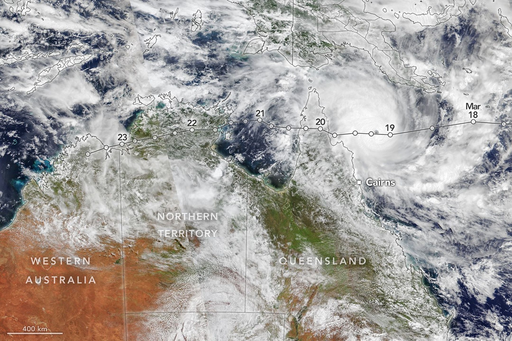
Cyclone Narelle’s Remarkable Journey Across Australia
Tropical Cyclone Narelle followed one of the most unusual paths in recorded Australian history. It became only the third storm system (and the first in over 20 years) to make landfall in three different Australian jurisdictions.
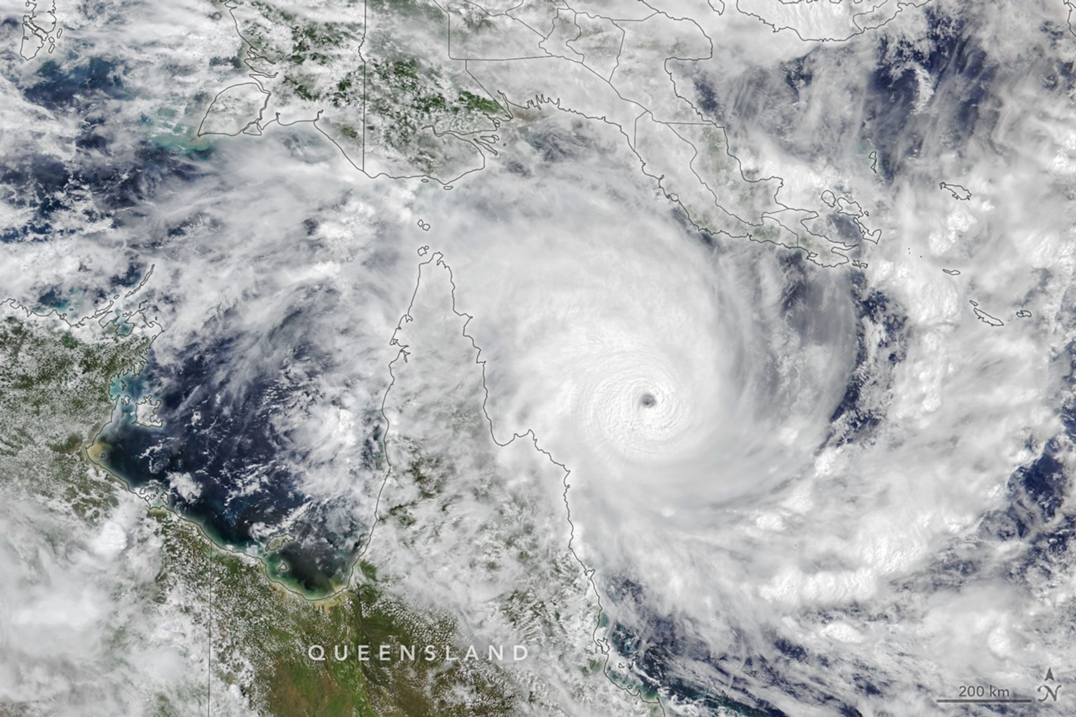
March 20, 2026: Narelle made its first landfall in far north Queensland as a high-end Category 4 system (with gusts up to 225 km/h), lashing Cape York Peninsula with destructive winds, heavy rain, and storm surge. It crossed as a Category 3 before moving into the Gulf of Carpentaria.
Tropical Cyclone Narelle Crosses Australia.
It then tracked across the Northern Territory, bringing torrential rain and flooding to parts of the Top End.
After weakening and crossing the Indian Ocean, the system re-intensified. By late March, it threatened Western Australia’s Pilbara and Gascoyne coasts as a severe Category 3–4 system, with destructive wind gusts approaching 250–260 km/h and dangerous storm surges.
Tropical Cyclone Narelle Crosses Australia.
The cyclone’s compact but intense core, combined with its long journey (over 5,500–5,700 km), made it a significant weather event. It made a third landfall in Western Australia near the Gascoyne or Pilbara region around March 27–28, bringing heavy rainfall, strong winds, and the dust-laden conditions that produced the red skies.

Cyclone Narelle: What it means for Queensland and the Great Barrier Reef.
Cyclone Narelle: What it means for Queensland and the Great Barrier Reef.
By March 29–30, the system had been downgraded to a subtropical low in some areas, but its impacts lingered with flash flooding risks, particularly in Perth and surrounding regions where rain bands delivered several times the average March rainfall.
Impacts and Community Response
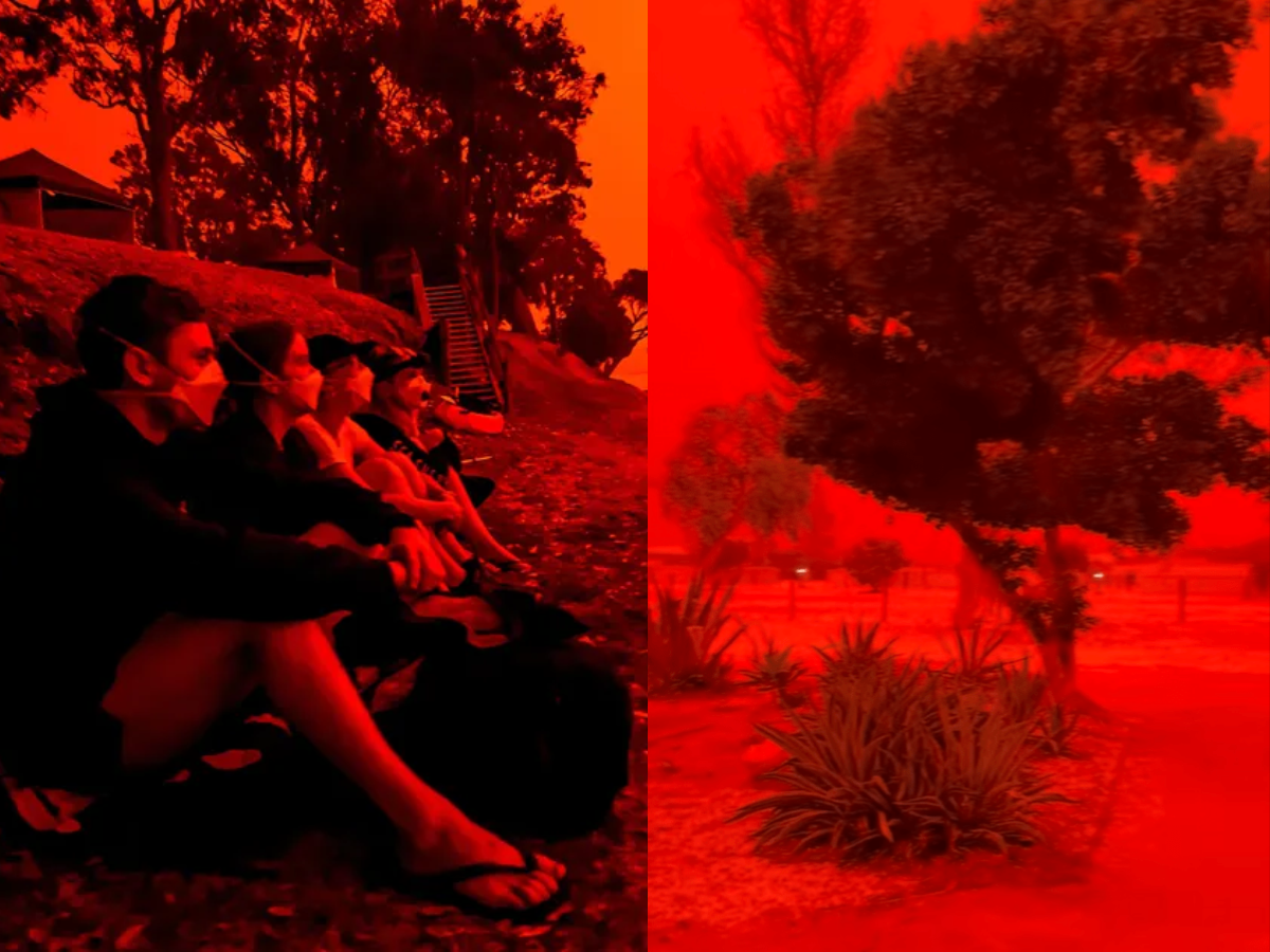
In Western Australia, the red sky added a psychological layer to the cyclone threat. Residents in Shark Bay, Denham, Exmouth, Carnarvon, and Karratha prepared for destructive winds, intense rainfall, and potential power outages. Emergency services issued warnings for storm surge, flash flooding, and hazardous driving conditions due to reduced visibility from dust.
The Pilbara region, home to major mining and LNG operations, monitored the storm closely for disruptions. Communities followed lockdown protocols in some coastal towns, securing properties and heeding evacuation advice where necessary.
In Queensland and the Northern Territory, earlier impacts included heavy rainfall (over 200 mm in 24 hours in some spots), localised flooding, and wind damage. The Great Barrier Reef faced risks from the initial landfall, though the cyclone’s path spared the most sensitive central sections from the worst effects.
The “triple-strike” nature of Narelle highlighted the vast scale of Australia’s tropical cyclone season and the challenges of forecasting systems that can re-intensify over warm waters after crossing land.
Why Such Events Feel Apocalyptic
Beyond the science, the visual impact of a blood-red sky taps into deep human instincts. Throughout history, red skies at unusual times have been interpreted as omens or warnings. In this case, the combination of an approaching powerful cyclone and the dust-induced crimson glow amplified the sense of foreboding.
Social media exploded with videos from Shark Bay and Karratha, with many users noting how the scene resembled scenes from dystopian films. Meteorologists and the Bureau of Meteorology (BOM) worked quickly to explain the phenomenon, reassuring the public that while dramatic, it was a natural consequence of the cyclone’s winds interacting with the red desert soils of the Australian outback.
Broader Context: Climate and Cyclone Behaviour
Tropical Cyclone Narelle occurred during a period of record warmth in parts of the Coral Sea and Indian Ocean. Warmer sea surface temperatures can fuel stronger cyclones and influence their intensity and longevity. While individual events cannot be directly attributed to climate change, scientists note that a warming climate may alter the behaviour, frequency, or intensity of tropical cyclones in the Australian region.
Narelle’s unusual path — crossing Queensland, the Northern Territory, and then Western Australia — underscored the complexity of weather systems influenced by upper-level troughs and steering patterns.
Looking Ahead
As Narelle weakened into a tropical low or subtropical system, attention turned to cleanup, recovery, and assessing damage across the affected regions. For residents in Western Australia, the red sky served as a dramatic prelude to the storm’s arrival, reminding everyone of nature’s raw power.
The event also provided a striking visual reminder of how interconnected atmospheric processes are — from distant ocean warmth energising the cyclone to inland dust being lifted and transformed into an unforgettable crimson spectacle.
Key Takeaways:
The blood-red sky resulted from Mie scattering of sunlight by iron-rich dust lifted by Cyclone Narelle’s winds.
Narelle made rare triple landfalls across Queensland, Northern Territory, and Western Australia.
The phenomenon was most pronounced in Shark Bay (near Denham) and Karratha in late March 2026.
While visually alarming, it was a natural event explained by atmospheric physics and the unique geology of Australia’s red desert regions.
This “apocalyptic” red sky will likely remain one of the most memorable images from the 2025–2026 Australian cyclone season — a powerful illustration of how weather systems can transform the everyday sky into something extraordinary and awe-inspiring.
Tropical Cyclone Narelle Crosses Australia.
Tropical Cyclone Narelle, Red Sky Australia, Shark Bay, Western Australia, Dust Storm, Apocalyptic Sky, Cyclone Science, 2026 Cyclone Season.
Comments
Post a Comment